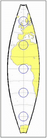
cassinistd
Cassini Cylindrical Projection — Standard
Identifier
cassinistd
Graticule
Central Meridian: Straight line (includes meridian opposite the central meridian in one continuous line).
Other Meridians: Straight lines if 90º from central meridian, complex curves concave toward the central meridian otherwise.
Parallels: Complex curves concave toward the nearest pole.
Poles: Points along the central meridian.
Symmetry: About any straight meridian or the Equator.
Features
This is a projection onto a cylinder tangent at the central meridian. Distortion of both shape and area are functions of distance from the central meridian. Scale is true along the central meridian and along any straight line perpendicular to the central meridian (i.e., it is equidistant).
Parallels
For cylindrical projections, only one standard parallel is specified. The other standard parallel is the same latitude with the opposite sign. For this projection, the standard parallel of the base projection is by definition fixed at 0º.
Remarks
This projection is the transverse aspect of the Plate Carrée projection, developed by César François Cassini de Thury (1714–1784). It is still used for the topographic mapping of a few countries.
cassinistdimplements the Cassini projection directly on a sphere or reference ellipsoid, as opposed to using the equidistant cylindrical projection in transverse mode as in functioncassini. Distinct forms are used for the sphere and ellipsoid, because approximations in the ellipsoidal formulation cause it to be appropriate only within a zone that extends 3 or 4 degrees in longitude on either side of the central meridian.Mapping Toolbox™ uses a different implementation of the standard Cassini cylindrical projection for displaying coordinates on
axesm-based maps than for projecting coordinates using theprojfwdorprojinvfunction. These implementations may produce differing results.
Example
landareas = shaperead('landareas.shp','UseGeoCoords',true);
axesm ('cassinistd', 'Frame', 'on', 'Grid', 'on');
geoshow(landareas,'FaceColor',[1 1 .5],'EdgeColor',[.6 .6 .6]);
tissot;
See also
Version History
Introduced before R2006a