eqdazim
Equidistant Azimuthal Projection
Classification
Azimuthal
Identifier
eqdazim
Graticule
The graticule described is for the polar aspect.
Meridians: Equally spaced straight lines intersecting at a central pole. The angles between them are the true angles.
Parallels: Equally spaced circles, centered on the central pole. The entire Earth may be shown.
Poles: Central pole is a point. The opposite pole is a bounding circle with a radius twice that of the Equator.
Symmetry: About any meridian.
Features
This is an equidistant projection. It is neither equal-area nor conformal. In the polar aspect, scale is true along any meridian. The projection is distortion free only at the center point. Distortion is moderate for the inner hemisphere, but it becomes extreme in the outer hemisphere.
Parallels
There are no standard parallels for azimuthal projections.
Remarks
This projection may have been first used by the ancient Egyptians for star charts. Several cartographers used it during the sixteenth century, including Guillaume Postel, who used it in 1581. Other names for this projection include Postel and Zenithal Equidistant.
Mapping Toolbox™ uses a different implementation of the equidistant azimuthal projection for displaying coordinates on
axesm-based maps than for projecting coordinates using theprojfwdorprojinvfunction. These implementations may produce differing results.The implementation of the equidistant azimuthal projection for displaying coordinates on
axesm-based maps is applicable only for coordinates that are referenced to a sphere. The implementation of the equidistant azimuthal projection for projecting coordinates using theprojfwdorprojinvfunction is applicable for coordinates referenced to either a sphere or an ellipsoid.
Limitations
This projection is available only on the sphere.
Example
landareas = shaperead('landareas.shp','UseGeoCoords',true);
axesm ('eqdazim', 'Frame', 'on', 'Grid', 'on');
geoshow(landareas,'FaceColor',[1 1 .5],'EdgeColor',[.6 .6 .6]);
tissot;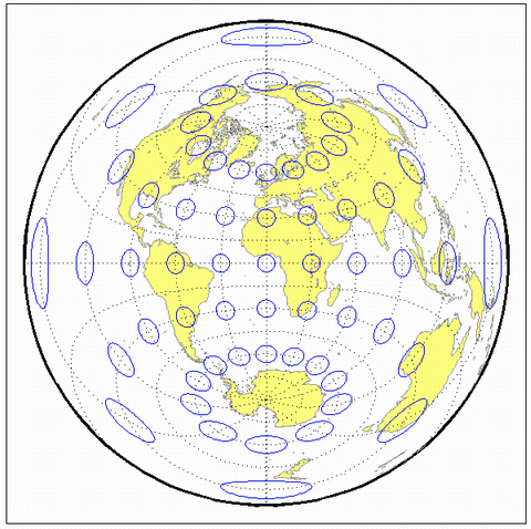
Version History
Introduced before R2006a