Use the Transverse Aspect to Map Across UTM Zones
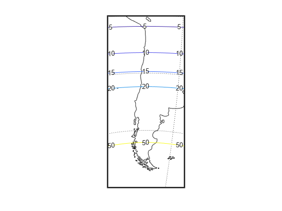
To display areas that extend across more than one UTM zone, use the Mercator projection in a transverse aspect. UTM is a zone-based coordinate system and is designed to be used like a map series, selecting from the appropriate sheet. While it is possible to extend one zone's coordinates into a neighboring zone's territory, this is not normally done. This example shows a transverse Mercator projection appropriate to Chile. In the example, note how the projection's line of zero distortion is aligned with the predominantly north-south axis of the country. Of course, you do not obtain coordinates in meters that would match those of a UTM projection, but the results will be nearly as accurate. To place the zero distortion line exactly on the midline of the country, use better estimates of the orientation vector's central meridian and orientation angle.
Set up an axesm-based map with a transverse aspect and display a map of Chile. Calculate the map distortion.
figure;
latlim = [-60 -15];
centralMeridian = -70;
width = 20;
axesm("mercator","Origin",[0 centralMeridian -90], ...
      "Flatlimit",[-width/2 width/2],"Flonlimit",sort(-latlim), ...
      "Aspect","transverse");
land = readgeotable("landareas.shp");
geoshow(land,"FaceColor","none")
framem
gridm
setm(gca,"plinefill",1000)
tightmap
mdistort scale
You might receive warnings about points from landareas.shp falling outside the valid projection region. You can ignore such warnings.