lambertstd
Lambert Conformal Conic Projection — Standard
Classification
Conic
Identifier
lambertstd
Graticule
Meridians: Equally spaced straight lines converging at one of the poles. The angles between the meridians are less than the true angles.
Parallels: Unequally spaced concentric circular arcs centered on the pole of convergence. Spacing of parallels increases away from the central latitudes.
Poles: The pole nearest a standard parallel is a point, the other cannot be shown.
Symmetry: About any meridian.
Features
lambertstd implements the Lambert Conformal
Conic projection directly on a reference ellipsoid, consistent with
the industry-standard definition of this projection. See lambert for
an alternative implementation based on rotating the authalic sphere.
Scale is true along the one or two selected standard parallels. Scale is constant along any parallel and is the same in every direction at any point. This projection is free of distortion along the standard parallels. Distortion is constant along any other parallel. This projection is conformal everywhere but the poles; it is neither equal-area nor equidistant.
Parallels
The cone of projection has interesting limiting forms. If a pole is selected as a single standard parallel, the cone is a plane, and a Stereographic Azimuthal projection results. If two parallels are chosen, not symmetric about the Equator, then a Lambert Conformal Conic projection results. If a pole is selected as one of the standard parallels, then the projected pole is a point, otherwise the projected pole is an arc. If the Equator or two parallels equidistant from the Equator are chosen as the standard parallels, the cone becomes a cylinder, and a Mercator projection results. The default parallels are [15 75].
Remarks
This projection was presented by Johann Heinrich Lambert in 1772 and is also known as a Conical Orthomorphic projection.
Mapping Toolbox™ uses a different implementation of the standard Lambert conformal conic projection for displaying coordinates on
axesm-based maps than for projecting coordinates using theprojfwdorprojinvfunction. These implementations may produce differing results.
Limitations
Longitude data greater than 135º east or west of the central meridian is trimmed. The default map limits are [0 90] to avoid extreme area distortion.
Example
landareas = shaperead('landareas.shp','UseGeoCoords',true);
axesm ('lambertstd', 'Frame', 'on', 'Grid', 'on');
geoshow(landareas,'FaceColor',[1 1 .5],'EdgeColor',[.6 .6 .6]);
tissot;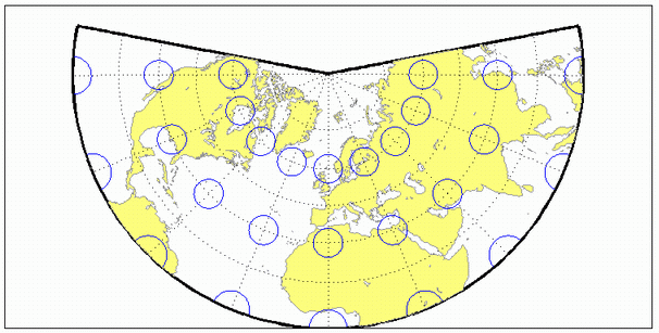
See Also
Version History
Introduced before R2006a