Main Content

mappointshape

Point shape in planar coordinates

Since R2021b

Description

A mappointshape object represents a point or multipoint in planar coordinates. A multipoint is an individual point shape that contains a set of point locations.

To represent a point or multipoint in geographic coordinates, use a geopointshape object instead.

Creation

To create mappointshape objects, either:

  • Import point data in planar coordinates as a geospatial table using the readgeotable function, and then query the Shape variable of the table.

  • Use the mappointshape function (described here).

Description

example

shape = mappointshape(x,y) creates a mappointshape object or array of mappointshape objects with the specified x- and y-coordinates. The sizes of x, y, and the mappointshape object array shape match.

Input Arguments

expand all

x-coordinates, specified as a numeric array or a cell array of numeric arrays.

  • Create a point by specifying a scalar, such as 39.

  • Create a multipoint by specifying an array within a cell, such as {[38 -30 29]}.

  • Create an array of points by specifying an array, such as [38 -30 29].

  • Create an array of points and multipoints by specifying a cell array of numeric arrays, such as {39,[38 -30 29]}.

Create placeholders for points with missing data by including NaN values. The NaN values in x must correspond to the NaN values in y.

The size of x must match the size of y. For cell arrays, the size of the array in each cell of x must match the size of the array in the corresponding cell of y.

Data Types: double | cell

y-coordinates, specified as a numeric array or a cell array of numeric arrays.

  • Create a point by specifying a scalar, such as -113.

  • Create a multipoint by specifying an array within a cell, such as {[-66 -31 42]}.

  • Create an array of points by specifying an array, such as [-66 -31 42].

  • Create an array of points and multipoints by specifying a cell array of numeric arrays, such as {-113,[-66 -31 42]}.

Create placeholders for points with missing data by including NaN values. The NaN values in x must correspond to the NaN values in y.

The size of x must match the size of y. For cell arrays, the size of the array in each cell of x must match the size of the array in the corresponding cell of y.

Data Types: double | cell

Properties

expand all

This property is read-only.

Number of points, returned as an array of nonnegative integers.

For a mappointshape scalar, the value of NumPoints is 1 when the mappointshape object represents a single point and more than 1 when the object represents a multipoint.

For a mappointshape array, the size of NumPoints matches the size of the array.

Data Types: double

x-coordinates, specified as an array.

For a mappointshape scalar, the size of X matches the value of NumPoints.

For a mappointshape array, the size of X matches the size of NumPoints. If the array contains mappointshape objects with multipoints, then accessing the X property of the array is not supported. Instead, access the X property of individual objects within the array. You can determine whether a mappointshape array contains multipoints by using the ismultipoint function.

This property is read-only for arrays when any element of NumPoints is greater than 1.

X and Y must be the same size.

Data Types: double

y-coordinates, specified as an array.

For a mappointshape scalar, the size of Y matches the value of NumPoints.

For a mappointshape array, the size of Y matches the size of NumPoints. If the array contains mappointshape objects with multipoints, then accessing the Y property of the array is not supported. Instead, access the Y property of individual objects within the array. You can determine whether a mappointshape array contains multipoints by using the ismultipoint function.

This property is read-only for arrays when any element of NumPoints is greater than 1.

X and Y must be the same size.

Data Types: double

This property is read-only.

Geometric type, returned as "point".

Data Types: string

This property is read-only.

Coordinate system type, returned as "planar".

Data Types: string

Projected coordinate reference system (CRS), specified as a projcrs object. A projected CRS consists of a geographic CRS and several parameters that are used to transform coordinates to and from the geographic CRS.

Object Functions

geoplotPlot points, lines, and polygons on map
mapclipClip shape to xy-limits in planar coordinates
ismultipointDetermine which array elements are multipoint shapes

Examples

collapse all

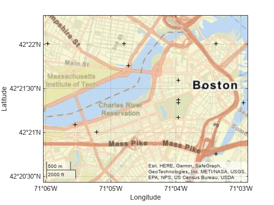
Import a shapefile containing the coordinates of locations in Boston as a geospatial table. The shapefile represents the locations using points. Get information about the points by querying the Shape variable of the table.

GT = readgeotable("boston_placenames.shp");
GT.Shape
ans = 
  13×1 mappointshape array with properties:

               NumPoints: [13×1 double]
                       X: [13×1 double]
                       Y: [13×1 double]
                Geometry: "point"
    CoordinateSystemType: "planar"
            ProjectedCRS: [1×1 projcrs]

Display the locations using black plus signs on a road map.

geoplot(GT,"+k")
geobasemap streets

Create an individual point as a mappointshape scalar. Specify the projected CRS as World Equidistant Cylindrical, which has the EPSG authority code 4087.

point = mappointshape(-113,39);
p = projcrs(4087);
point.ProjectedCRS = p
point = 
  mappointshape with properties:

               NumPoints: 1
                       X: -113
                       Y: 39
                Geometry: "point"
    CoordinateSystemType: "planar"
            ProjectedCRS: [1x1 projcrs]

Create a multipoint as a mappointshape scalar.

multipoint = mappointshape({[-66 -31 42]},{[38 -30 29]});
multipoint.ProjectedCRS = p
multipoint = 
  mappointshape with properties:

               NumPoints: 3
                       X: [-66 -31 42]
                       Y: [38 -30 29]
                Geometry: "point"
    CoordinateSystemType: "planar"
            ProjectedCRS: [1x1 projcrs]

Create three individual points as a 1-by-3 mappointshape array.

pointVector = mappointshape([-66 -31 42],[38 -30 29]);
pointVector.ProjectedCRS = p
pointVector = 
  1x3 mappointshape array with properties:

               NumPoints: [1 1 1]
                       X: [-66 -31 42]
                       Y: [38 -30 29]
                Geometry: "point"
    CoordinateSystemType: "planar"
            ProjectedCRS: [1x1 projcrs]

Create one individual point and one multipoint as a 1-by-2 mappointshape array.

pointMultipoint = mappointshape({-113,[-66 -31 42]},{39, [38 -30 29]});
pointMultipoint.ProjectedCRS = p
pointMultipoint = 
  1x2 mappointshape array with properties:

               NumPoints: [1 3]
                Geometry: "point"
    CoordinateSystemType: "planar"
            ProjectedCRS: [1x1 projcrs]

Version History

Introduced in R2021b

expand all