northarrow
在基于 axesm 的地图上添加北向箭头
语法
northarrow

northarrow('property',value,...)
说明
northarrow 创建默认的指北针。
northarrow('property',value,...) 使用指定的属性/值对创建指北针。属性有效输入为 'latitude'、'longitude'、'facecolor'、'edgecolor'、'linewidth' 和 'scaleratio'。'latitude' 和 'longitude' 属性指定了北箭头的方位位置。'facecolor'、'edgecolor' 和 'linewidth' 属性控制指北针的外观。'scaleratio' 属性表示北箭头的大小占坐标区大小的比例。当 'scaleratio' 值设为 0.10 时,将生成一个大小为坐标区十分之一(1/10)的指北针。您可以使用 set 命令更改指北针的外观('facecolor'、'edgecolor' 和 'linewidth')。
northarrow 函数在显示地图的地图原点处创建一个指北针符号。您可以通过点击并拖动北箭头图标来重新定位它。或者,通过右键点击或按住 Ctrl 并用左键点击箭头,打开一个对话框,用于更改北箭头的方位。无论您将符号移动到何处,北箭头的方向都会自动计算,无需手动调整。
修改北箭头的某些属性会导致原始对象被替换。使用 HANDLEM('NorthArrow') 获取与北箭头关联的句柄。
示例
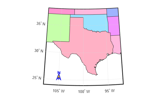
绘制一张德克萨斯州地图。在地图左下角添加北箭头。
figure
usamap("texas")
states = readgeotable("usastatelo.shp");
faceColors = makesymbolspec("Polygon",...
         {'INDEX',[1 numel(states)],'FaceColor',polcmap(height(states))});
geoshow(states,"DisplayType","polygon","SymbolSpec",faceColors)
northarrow("Latitude",25,"Longitude",-105,"LineWidth",1.5);

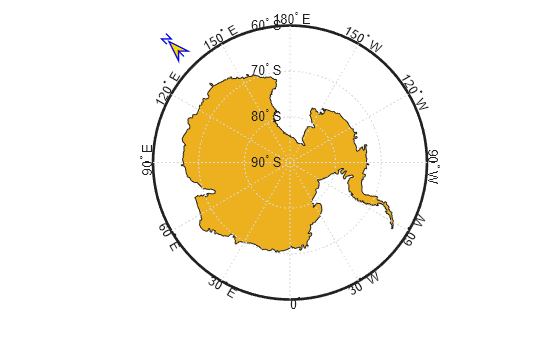
更改指北针的边框和填充颜色。
h = handlem("NorthArrow");
set(h,"FaceColor",[1 0.8431 0],"EdgeColor",[0.01 0.01 0.9])
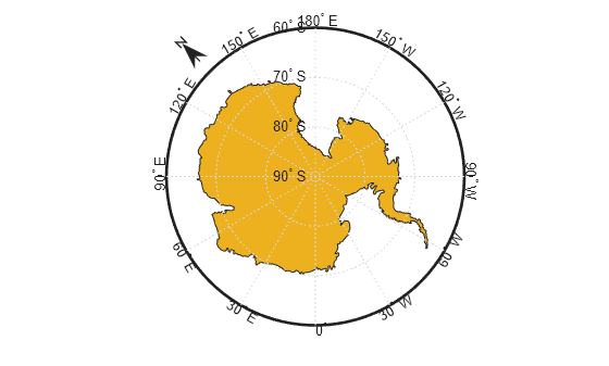
创建以南极点为中心的地图。在指定地理位置添加指北针。
GT = readgeotable("landareas.shp");
antarctica = GT(GT.Name == "Antarctica",:);
figure
worldmap("south pole")
geoshow(antarctica)
northarrow("latitude",-57,"longitude",135);
更改北箭头的外观。
h = handlem("NorthArrow");
set(h,"FaceColor", [1.000 0.8431 0.0000], ...
      "EdgeColor", [0.0100 0.0100 0.9000])
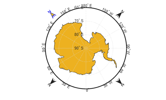
通过再画三支北箭,证明从南极出发的每个方向都是北。请注意,北箭头是坐标区中的对象,采用笛卡尔坐标系,而非映射对象。因此,若创建多个指北针,任何操作指北针的 Mapping Toolbox™ 函数都仅会影响最后绘制的那个。
northarrow("latitude",-57,"longitude", 45);
northarrow("latitude",-57,"longitude",225);
northarrow("latitude",-57,"longitude",315);
限制
您可以在地图上绘制多个指北针。然而,回调函数仅对最近创建的指北针有效。此外,由于指北针可显示在地图边框之外,因此不会将其转换为“映射”对象。因此,当地图原点或投影发生变化时,必须手动更新北箭头的方位和方向。
版本历史记录
在 R2006a 之前推出