tissot
R2026b基于 axesm 的地图上的“Tissot 指示器”工程
语法
h = tissot

h = tissot(spec)

h = tissot(spec,linetype)

h = tissot(linestyle)

h = tissot(spec,PropertyName,PropertyValue,...)

 h = tissot(linetype,PropertyName,PropertyValue,...)
描述
h = tissot 会在当前基于 axesm 的地图上绘制如上所述的默认蒂索图,并返回所显示的指示线的句柄。
h = tissot(spec) 允许您按照上述说明,指定所显示的蒂索图的绘图参数。
h = tissot(spec,linetype) 和 h = tissot(linestyle) 用于指定线条样式和颜色。
h = tissot(spec, 和 PropertyName,PropertyValue,...) h = tissot(linetype, 允许指定 PropertyName,PropertyValue,...)line 函数所识别的任何属性及其值。
背景
天梭指示符是一类绘图符号,有助于理解特定地图投影中的各种畸变。指示线是地球表面上真实半径相同的圆。将它们绘制在地图投影上时,可以表明该投影是否具有某些特征。如果绘制出的指标线所包围的面积均相等,则该投影为等面积投影(例如,正弦投影就具有这一特征)。如果它们都保持圆形,则表明具有共形性(墨卡托投影具有这一属性)。子午线或纬向距离的畸变表现为扁平或拉长的指示线。许多投影图在某些区域(通常靠近中心)会显示出非常规整、呈圆形的指示线,而在其他区域(例如靠近边缘处)则会显示出严重畸变的指示线。因此,蒂索图在分析某种投影法是否适用于特定目的或特定地区方面非常有用。
Tissot 图的总体布局由规格向量 spec 确定。
spec = [Radius]
spec = [Latint,Longint]
spec = [Latint,Longint,Radius]
spec = [Latint,Longint,Radius,Points]
Radius 是每个指示圆的小圆半径。如果输入该值,其单位应与基于 axesm 的地图 Geoid 保持一致。默认半径为该球体半径的十分之一。
Latint 是指示圆中心之间的纬度间隔。如果要输入,应使用基于 axesm 的映射 AngleUnits。默认值为每 30º纬度对应一个圆(即 0º、±30º等)。
Longint 是指示圆中心之间的经度间隔。如果要输入,应使用基于 axesm 的映射 AngleUnits。默认值为每 30º纬度对应一个圆(即 0º、±30º等)。
Points 表示每个圆的绘图点数。默认值为 100 个点。
示例
axesm sinusoid; framem
tissot
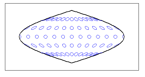
正弦投影是一种等面积投影法。
setm(gca,'MapProjection','Mercator')
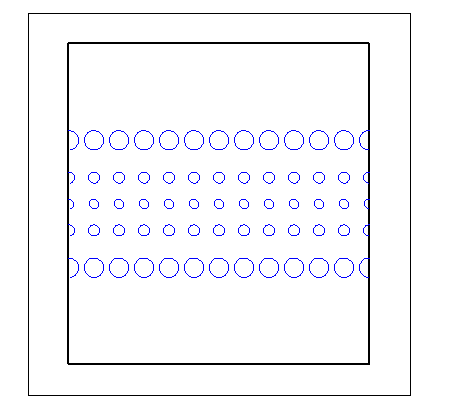
墨卡托投影是一种等角投影。
详细信息
请以字符向量或包含符号的字符串的形式指定线条样式和颜色。符号可以按任何顺序显示。您无需指定颜色。例如,使用 'r--' 指定一条红色的虚线。
| 线型 | 描述 | 生成的线条 |
|---|---|---|
'-' | 实线 |
|
'--' | 虚线 |
|
':' | 点线 |
|
'-.' | 虚线 |
|


| 颜色名称 | 简称 | 外观 |
|---|---|---|
'red' | 'r' |
|
'green' | 'g' |
|
'blue' | 'b' |
|
'cyan' | 'c' |
|
'magenta' | 'm' |
|
'yellow' | 'y' |
|
'black' | 'k' |
|
'white' | 'w' |
|








版本历史记录
在 R2006a 之前推出

