WMSLayer
Web Map Service layer
Description
A WMSLayer object describes a Web Map Service (WMS) layer
or layers.
Creation
You can create a WMSLayer object using any of the following
methods:
wmsfind— Returns aWMSLayerarray.wmsinfo— Returns aWMSCapabilitiesobject, which contains an array ofWMSLayerobjects in itsLayerproperty.The
WMSLayerobject creation function, described here.
Description
layers = WMSLayer(
constructs a Name,Value)WMSLayer object, where Name
is the name of any property of the WMSLayer and
Value is the value that you want to assign to the
property. You can specify several name-value pair arguments in any order as
Name1,Value1,...,NameN,ValueN. The size of the output
layers is scalar unless all inputs are cell arrays, in
which case, the size of layers matches the size of the cell
arrays.
Properties
This property is read-only.
Descriptive information about the server, returned as a character vector.
Data Types: char
This property is read-only.
URL of WMS Server, returned as a character vector.
Data Types: char
This property is read-only.
Descriptive information about the layer, returned as a character vector.
The LayerTitle clarifies the meaning of the raster values
of the layer.
Data Types: char
This property is read-only.
Keyword the server uses to retrieve the layer, returned as a character vector.
Data Types: char
Latitude limits of the layer in units of degrees, specified as a two-element numeric vector. The limits specify the southern and northern latitude limits and must be in units of degrees and in the range [-90, 90].
Data Types: double
Longitude limits of the layer in units of degrees, specified as a two-element numeric vector. The limits specify the western and eastern longitude limits and must be ascending and in the range [-180, 180] or [0, 360].
Data Types: double
This property is read-only.
Information about the layer, returned as a character vector.
Data Types: char
This property is read-only.
Codes identifying available coordinate reference systems, returned as a cell array of character vectors.
Data Types: cell
This property is read-only.
Detailed information about the layer, returned as a structure containing these fields:
| Field | Description |
|---|---|
MetadataURL | URL containing metadata information about the layer, returned as a character vector. |
Attributes | Attributes of the layer, returned as a structure array containing these fields.
|
BoundingBox | Bounding box of the layer, returned as a structure array containing these fields.
|
Dimension | Dimension parameters, returned as a structure array containing these fields. Examples of dimensions include time, elevation, and temperature.
|
ImageFormats | Image formats supported by the server, returned as a cell array of character vectors. |
ScaleLimits | Scale limits of the layer, returned as a structure containing these fields.
|
Style | Style parameters that determine layer rendering, returned as a structure array containing these fields.
|
Version | WMS version specification, returned as a character vector. |
Data Types: struct
Object Functions
disp | Display properties of WMS layers or capabilities |
refine | Refine search of WMS layers |
refineLimits | Refine search of WMS layers based on geographic limits |
servers | Return URLs of unique WMS servers |
serverTitles | Return titles of unique WMS servers |
Examples
Specify the URL of a WMS server. You can typically find the host and path components of the URL via an internet search.
host = "www.mrlc.gov";
path = "/geoserver/NLCD_Land_Cover/wms?";
serverURL = "https://" + host + path;
Specify the name of the layer. You can typically find the name of a layer via an internet search.
layerName = "mrlc_display:NLCD_2016_Land_Cover_L48";Create the WMS layer from the URL of the WMS server and the layer name.
layer = WMSLayer(ServerURL=serverURL,LayerName=layerName);
Synchronize the layer with the server by using the wmsupdate function. Valid WMS layers have longitude limits in the range [–180, 180] or [0, 360]. Specify valid longitude limits for the layer by changing the Lonlim property.
layer = wmsupdate(layer);
layer.Lonlim = [-180 180];
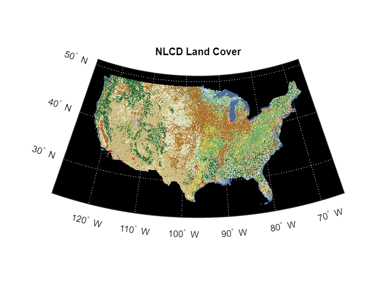
Read an image from the WMS server by using the wmsread function. Specify the latitude and longitude limits using the Latlim and Lonlim name-value arguments. Specify the height and width of the image using the ImageHeight and ImageWidth name-value arguments.
lonlim = [-128 -65];
latlim = [23 51];
height = 470;
width = 1024;
[A,R] = wmsread(layer,Latlim=latlim,Lonlim=lonlim,ImageHeight=height,ImageWidth=width);
Display the image from the server.
figure
usamap(A,R)
geoshow(A,R)
title("NLCD Land Cover")
You can also read the image by specifying a WMS GetMap request URL. Note that the URL contains the layer name in the LAYERS parameter, the latitude and longitude limits in the BBOX parameter, and the size of the image in the WIDTH and HEIGHT parameters.
requestURL = serverURL + "SERVICE=WMS&FORMAT=image/jpeg&REQUEST=GetMap&" + ...
  "STYLES=&SRS=EPSG:4326&VERSION=1.1.1&LAYERS=mrlc_display:NLCD_2016_Land_Cover_L48&" + ...
  "WIDTH=1024&HEIGHT=470&BBOX=-128,23,-65,51";
[A,R] = wmsread(requestURL);
Version History
Introduced in R2009b
See Also
Functions
Objects
MATLAB Command
You clicked a link that corresponds to this MATLAB command:
Run the command by entering it in the MATLAB Command Window. Web browsers do not support MATLAB commands.
选择网站
选择网站以获取翻译的可用内容,以及查看当地活动和优惠。根据您的位置,我们建议您选择:。
您也可以从以下列表中选择网站:
如何获得最佳网站性能
选择中国网站(中文或英文)以获得最佳网站性能。其他 MathWorks 国家/地区网站并未针对您所在位置的访问进行优化。
美洲
- América Latina (Español)
- Canada (English)
- United States (English)
欧洲
- Belgium (English)
- Denmark (English)
- Deutschland (Deutsch)
- España (Español)
- Finland (English)
- France (Français)
- Ireland (English)
- Italia (Italiano)
- Luxembourg (English)
- Netherlands (English)
- Norway (English)
- Österreich (Deutsch)
- Portugal (English)
- Sweden (English)
- Switzerland
- United Kingdom (English)