标准文件格式
读取、写入地理空间数据文件并获取相关信息。有关支持的文件格式信息,请参阅 支持导入和导出的地理空间文件格式。
函数
对象
RasterInfo | Information about geospatial raster data file |
RPCCoefficientTag | 有理多项式系数标签 |
主题
- Functions That Read and Write Geospatial Data
Functions that read and write geospatial file formats and geospatial data products.
- Read Data from OpenStreetMap Files
OpenStreetMap® files identify locations using tags. Extract information from OpenStreetMap files based on their tags. (自 R2023b 起)
- Data Stored in OpenStreetMap Layers
This topic describes the data stored in each layer of an OpenStreetMap file. (自 R2023b 起)
- Display Buildings from OpenStreetMap Files
Read buildings from OpenStreetMap files. Visualize the buildings and their attributes using colors and data tips. (自 R2023b 起)
- Export Vector Geodata
You can export geodata as a shapefile, which can be exchanged between different geographic information systems. You can also create KML files to upload geodata to the web.
- Select Shapefile Data to Read
Import a subset of elements in a shapefile by filtering elements according to attribute names and values.
精选示例
Exporting Vector Data to KML
Structure geographic point, line, and polygon vector data and export the data to a KML file.

Export Images and Raster Grids to GeoTIFF
Write data referenced to standard geographic and projected coordinate systems to GeoTIFF files.

Create, Process, and Export Digital Surface Model from Lidar Data
Create a digital surface model (DSM) from aerial lidar data, reference the model to projected coordinates, update the model, and export the result to a GeoTIFF file.
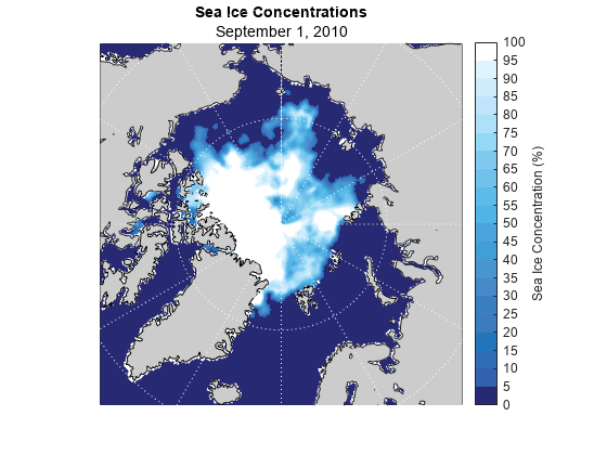
Visualize Sea Ice Concentrations from GRIB Data
Read sea ice concentrations from a GRIB file and visualize the data using a 2-D map, an animated GIF, and histograms.