roadprops
Syntax
Description
Add-On Required: This feature requires the Scenario Builder for Automated Driving Toolbox add-on.
OpenDRIVE
roadProperties = roadprops(OpenDrive=filename)
OpenStreetMap
[
extracts road properties and the geographic reference coordinates of a road network from
an OpenStreetMap® road network file.roadProperties,geoReference] = roadprops(OpenStreetMap=filename)
HERE HD Live Map
[
extracts road properties from a HERE HD Live Map1
(HDLM) web service. The function extracts properties of the roads that are
nearest to the latitude and longitude coordinates specified in roadProperties,geoReference] = roadprops("HEREHDLiveMap",lat,lon)lat
and lon, respectively.
[
extracts road properties for HERE HDLM roads that are at least partially within a
geographic bounding box specified by minimum and maximum latitude and longitude.roadProperties,geoReference] = roadprops("HEREHDLiveMap",minLat,minLon,maxLat,maxLon)
Zenrin Japan Map API 3.0 (Itsumo NAVI API 3.0)
[
extracts road parameters from a Zenrin Japan Map API 3.0 (Itsumo NAVI API 3.0)
2
web service. The function extracts the properties of the roads that are
nearest to the latitude and longitude coordinates specified in roadProperties,geoReference] = roadprops("ZenrinJapanMap",lat,lon)lat
and lon, respectively.
Importing roads from the Zenrin Japan Map API 3.0 (Itsumo NAVI API 3.0) service requires Automated Driving Toolbox Importer for Zenrin Japan Map API 3.0 (Itsumo NAVI API 3.0) Service.
[
extracts Zenrin Japan Map API 3.0 (Itsumo NAVI API 3.0) roads that are at least partially within a geographic bounding box specified
by minimum and maximum latitude and longitude.roadProperties,geoReference] = roadprops("ZenrinJapanMap",minLat,minLon,maxLat,maxLon)
Examples
Input Arguments
Name of the road network file, specified as a character vector or string scalar.
filename must specify a file in the current folder, a file that is
on the MATLAB® search path, or a full or relative path to a file.
filename must end with a file extension that is valid for the
source of the road network.
| Road Network Source | Valid File Extensions | Sample Syntax |
|---|---|---|
| OpenDRIVE |
|
roadprops(OpenDRIVE="C:\Desktop\roads.xodr") |
| OpenStreetMap |
|
roadprops(OpenStreetMap="C:\Desktop\map.osm") |
Latitude coordinates, specified as a vector of elements in the range [–90, 90].
lat must be the same size as lon. Units are
in degrees.
Longitude coordinates, specified as a vector of elements in the range [–180, 180].
lon must be the same size as lat. Units are
in degrees.
Minimum latitude coordinate of the bounding box, specified as a scalar in the range
[–90, 90]. minLat must be less than maxLat.
Units are in degrees.
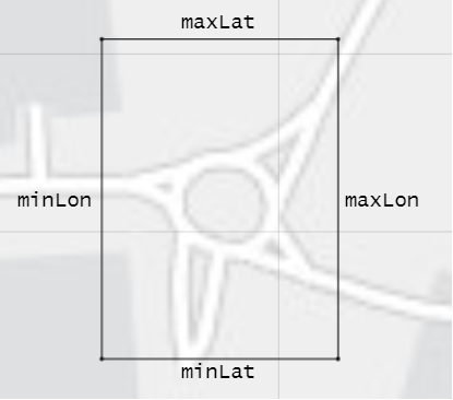
The roadprops function imports
any roads that are at least partially within the bounding box specified by inputs
minLat, minLon, maxLat,
and maxLon. This diagram displays the relationship between these coordinates.
Minimum longitude coordinate of the bounding box, specified as a scalar in the range
[–180, 180]. minLon must be less than maxLon.
Units are in degrees.
The roadprops function imports
any roads that are at least partially within the bounding box specified by inputs
minLat, minLon, maxLat,
and maxLon. This diagram displays the relationship between these coordinates.
Maximum latitude coordinate of the bounding box, specified as a scalar in the range
[–90, 90]. maxLat must be greater than minLat.
Units are in degrees.
The roadprops function imports
any roads that are at least partially within the bounding box specified by inputs
minLat, minLon, maxLat,
and maxLon. This diagram displays the relationship between these coordinates.
Maximum longitude coordinate of the bounding box, specified as a scalar in the range
[–180, 180]. maxLon must be greater than
minLon. Units are in degrees.
The roadprops function imports
any roads that are at least partially within the bounding box specified by inputs
minLat, minLon, maxLat,
and maxLon. This diagram displays the relationship between these coordinates.
Output Arguments
Version History
Introduced in R2022b
See Also
1 You need to enter into a separate agreement with HERE in order to gain access to the HDLM services and to get the required credentials (access_key_id and access_key_secret) for using the HERE Service.
2 To gain access to the Zenrin Japan Map API 3.0 (Itsumo NAVI API 3.0) service and get the required credentials (a client ID and secret key), you must enter into a separate agreement with ZENRIN DataCom CO., LTD.