Georeferenced Raster Data
Raster geodata consists of georeferenced data grids and images that are stored as matrices or objects in the MATLAB® workspace. While raster geodata looks like any other matrix of real numbers, what sets it apart is that it is georeferenced, either to the globe or to a specified map projection, so that each pixel of data occupies a known patch of territory on the planet.
All regular data grids require a reference object that specify the placement and resolution of the data set. Geolocated data grids do not require a separate reference object, as they explicitly identify the geographic coordinates of all rows and columns. For details on geolocated grids, see Geolocated Data Grids.
Reference Objects
For a 2-D raster of cells or posting point samples, a raster reference object describes the relationship between the intrinsic coordinate system for the raster and a geographic or planar (projected) map coordinate system. The object associates each element of the raster with a location in geographic or planar coordinates.
Reference objects are self-documenting and provide a rich set of properties to describe both the intrinsic and extrinsic geometry. There are four types of reference objects:
Use a
GeographicCellsReferencewhen the raster is a grid of quadrangular cells referenced to geographic latitude and longitude coordinates.Use a
GeographicPostingsReferencewhen the raster is a grid of posting point samples referenced to geographic coordinates.Use a
MapCellsReferencewhen the raster is a grid of rectangular cells referenced to projected world x- and y-coordinates.Use a
MapPostingsReferencewhen the raster is a grid of posting point samples referenced to projected coordinates.
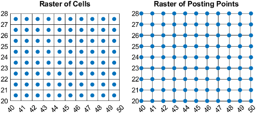
This image compares a projected raster of cells and a projected raster of posting points. Both rasters have elements that are spaced 1 meter apart, with the raster covering x-values in the range [40,50] in meters and y-values in the range [20,28] in meters. The boundary of the raster of cells is made up of the outermost boundaries of the outermost cells and the boundary of the raster of postings is made up of sampling points along the edges of the raster.