MapPostingsReference
Reference raster postings to map coordinates
Description
A map postings raster reference object contains information that describes the relationship between a planar map coordinate system and an intrinsic coordinate system that is anchored to the columns and rows of a 2-D spatially referenced grid of point samples (or postings).
Typically, the raster is sampled regularly in the planar world x- and world y-coordinates of the map system, such that the intrinsic x and world xaxes align and the intrinsic y and world y axes align. When this is true, the relationship between the two systems is rectilinear. More generally, and much more rarely, their relationship is affine. The affine relationship allows for a possible rotation (and skew). In either case, rectilinear or affine, the sample spacing from row to row need not equal the sample spacing from column to column.
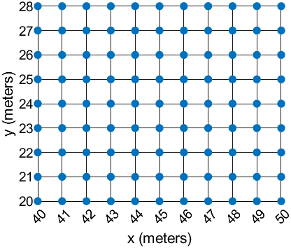
This image illustrates a 9-by-11 planar raster of postings. The postings are spaced 1 meter apart in x and y, cover x values in the range [40,50] in meters, and cover y values in the range [20,28] in meters. The boundary of the raster of postings is a rectangle with edges that pass through the outermost postings.

To reference a raster of cells to planar map coordinates, use a MapCellsReference object instead.
Creation
You can use these functions to create MapPostingsReference
objects:
readgeoraster— Import a raster data file as an array and a reference object.maprefpostings— Create a map raster reference object by specifying the x and y world limits of the raster and either the size of the raster or the spacing of the postings.maprasterref— Convert a world file to a map raster reference object.refmatToMapRasterReference— Convert a referencing matrix to a map raster reference object.
Properties
Object Functions
contains | Determine if geographic or map raster contains points |
cropToBlock | Crop raster reference object to row and column limits of raster |
firstCornerX | Return world x-coordinate of map raster index (1,1) |
firstCornerY | Return world y-coordinate of map raster index (1,1) |
intrinsicToWorld | Transform intrinsic to planar world coordinates |
sizesMatch | Determine if geographic or map raster object and image or raster are size-compatible |
worldFileMatrix | Return world file parameters for transformation |
worldGrid | World coordinates of raster elements |
worldToDiscrete | Transform planar world to discrete coordinates |
worldToIntrinsic | Transform planar world to intrinsic coordinates |
Examples
More About
Version History
Introduced in R2013b
