addCustomTerrain
R2026bAdd custom terrain data
Description
addCustomTerrain(
adds terrain data specified by terrainName,files)files for use with geographic
plotting functions such as geoglobe
and 3D scenario functions such as scenario. The terrain is named terrainName, and you
can specify it by this name when calling a plotting function. Custom terrain data is
available for current and future sessions of MATLAB®, until you call removeCustomTerrain.
addCustomTerrain(___,
specifies options using one or more name-value arguments in addition to the input
arguments in the previous syntax. For example, specify the location to write the
terrain data by using the Name=Value)WriteLocation argument.
Examples
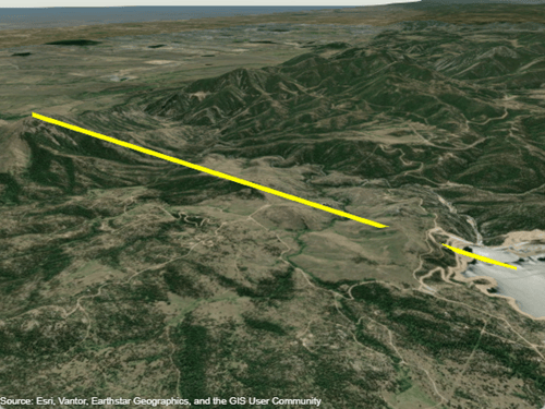
Display a line from the surface of Gross Reservoir to a point above South Boulder Peak using custom terrain.
First, add terrain for an area around South Boulder Peak by calling addCustomTerrain and specifying a DTED file. The DTED file is from the SRTM Void Filled data set, available from the US Geological Survey. Name the terrain "southboulderpeak".
addCustomTerrain("southboulderpeak","n39_w106_3arc_v2.dt1")
Create a geographic globe. Specify the terrain by name, using the Terrain argument of the geoglobe function. Then, plot the line. Tilt the view by holding Ctrl and dragging.
uif = uifigure;
g = geoglobe(uif,Terrain="southboulderpeak");

lat = [39.95384 39.95];
lon = [-105.29916 -105.3608];
hTerrain = [10 0];
geoplot3(g,lat,lon,hTerrain,"y",HeightReference="terrain",LineWidth=3)
Close the geographic globe and remove the custom terrain.
close(uif)
removeCustomTerrain("southboulderpeak")
Input Arguments
Name-Value Arguments
Tips
To deploy an application with custom terrain using MATLAB Compiler™, call
addCustomTerrainin the application and include the DTED files in the deployed application package.You can find and download DTED files by using EarthExplorer, a data portal provided by the US Geological Survey (USGS). From the list of data sets, search for DTED files by selecting Digital Elevation, SRTM, and then SRTM 1 Arc-Second Global and SRTM Void Filled.

