Web 地图服务
R2026b从 Web 地图服务 (WMS) 服务器获取地图数据
Web 地图服务 (WMS) 服务器通过网络源提供公开可用的地理空间数据,包括温度、海拔、天气、正射影像及人口统计数据。这些服务器遵循由 Open Geospatial Consortium, Inc.®(OGC) 制定的标准。使用 WMS 函数搜索包含服务器 URL、服务器标题、图层名称和图层标题的数据库,并从服务器读取 WMS 数据。
下图展示了来自 NASA SVS 图像服务器的对流层臭氧影响 WMS 地图、NOAA 的 ETOPO1 数据以及 Blue Marble:Next Generation 图像(来自美国宇航局 SVS 图像服务器)。

函数
类
WebMapServer | Web 地图服务器 |
WMSCapabilities | Web Map Service capabilities document |
WMSLayer | Web Map Service layer |
WMSMapRequest | Web Map Service map request |
主题
创建 WMS 地图
- Basic WMS Terminology
Learn about common terms encountered when working with Web Map Service (WMS), such as layers, capabilities documents, and WMS servers. - Basic Workflow for Creating WMS Maps
Create a WMS map by searching the WMS Database for servers and layers, requesting the most recent data associated with a layer, and displaying the data. - Create WMS Maps When Internet Access Is Intermittent
Create and save WMS maps, while accounting for intermittent internet access, by reading saved WMS maps from a file.
搜索层
- 探索同一服务器上的图层
在 WMS 数据库中查找一个图层,然后在同一 WMS 服务器上搜索类似的图层。 - Search for Layers Outside the WMS Database
Search for layers outside the WMS Database by using a search engine in your web browser.
显示层
- Overlay Multiple WMS Layers
Merge data from multiple layers, including data in mixed vector and raster formats, into a single raster map. - Add Legend to WMS Map
Download a legend from a WMS server and add it to a WMS map. - Animate Data from WMS Layers
Create maps of the same geographic region at different times and view the maps as a movie. - 在 GOES 背景上显示雷达图像的动画
在背景上播放每小时采集一次的雷达图像动画。 - Add Custom Basemaps from WMS Data
Add custom basemaps from WMS layers or from URLs that specify WMS GetMap requests. (自 R2024b 起)
读取 WMS 地图
- Modify Your WMS Map Request
Modify the geographic extent and time of a map request. - Read WMS Maps Using Different Coordinate Reference Systems
Read WMS maps using Web Mercator coordinates. - Read Quantitative Data from WMS Server
Retrieve quantitative data, for example terrain elevations, instead of an image from a WMS server.
导出 WMS 层
- Write WMS Layers to KML File
Render a map in a non-image format, such as KML.
疑难解答
Learn about connection errors, other common WMS server errors, and suggested workarounds.
精选示例
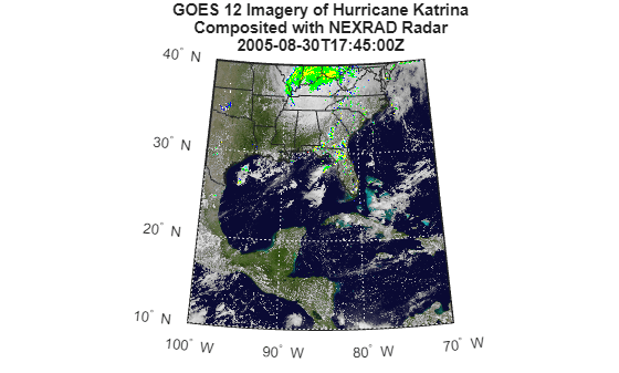
Composite and Animate Web Map Service (WMS) Meteorological Layers
Composite and animate data from multiple Web Map Service (WMS) layers.

