Main Content

binaryOccupancyMap

Create 2-D binary occupancy map from robot scenario

Since R2022a

    Description

    map = binaryOccupancyMap(scenario,Name=Value) creates binary occupancy map based on mesh elements from scenario defined with IsBinaryOccupied status true. The mesh elements are processed in the 3-D convex hull form. Further, mesh element is considered as occupied region only if it lies inside map height limits and map size. These properties are specified by one or more name-value pair arguments.

    example

    Examples

    collapse all

    Create a robot scenario.

    scenario = robotScenario(UpdateRate=1,StopTime=10);

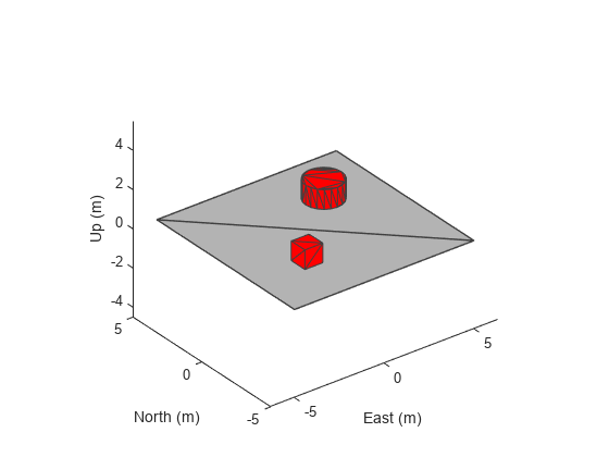
    Add a plane, box and cylinder mesh in the scenario.

    addMesh(scenario,"Plane",Size=[10 10],Color=[0.7 0.7 0.7])
    addMesh(scenario,"Box",Position=[-2 -2 0.5],IsBinaryOccupied=true)
    addMesh(scenario,"Cylinder",Position=[2 2 0.5],IsBinaryOccupied=true)

    Visualize the scenario.

    show3D(scenario);

    Figure contains an axes object. The axes object with xlabel East (m), ylabel North (m) contains 3 objects of type patch.

    Get the 2-D occupancy map.

    occupancyMap = binaryOccupancyMap(scenario,MapHeightLimits=[-1 1], ...
                                      GridOriginInLocal=[-5 -5]);

    Visualize the 2-D occupancy map.

    figure
    show(occupancyMap);

    Figure contains an axes object. The axes object with title Binary Occupancy Grid, xlabel X [meters], ylabel Y [meters] contains an object of type image.

    Input Arguments

    collapse all

    Robot scenario, specified as a robotScenario object.

    Name-Value Arguments

    Specify optional pairs of arguments as Name1=Value1,...,NameN=ValueN, where Name is the argument name and Value is the corresponding value. Name-value arguments must appear after other arguments, but the order of the pairs does not matter.

    Before R2021a, use commas to separate each name and value, and enclose Name in quotes.

    Example: map = binaryOccupancyMap(scenario,MapResolution=15)

    Origin of occupancy map grid in local coordinates, specified as a two-element vector of the form [xLocal yLocal] in meters.

    Data Types: single | double

    Resolution of occupancy map grid in z-axis, specified as a scalar integer in cells per meter.

    Data Types: single | double

    Minimum and maximum values of map height, specified as a two-element vector of the form [Hmin Hmax] in meters, from which static meshes are considered for occupancy map grid.

    Data Types: single | double

    Resolution of occupancy map grid in xy-axis, specified as a scalar integer in cells per meter.

    Data Types: single | double

    Size of occupancy map grid, specified as a two-element vector of the form [width height] in meters.

    Data Types: single | double

    Output Arguments

    collapse all

    Binary occupancy map from robot scenario, returned as a binaryOccupancyMap object.

    Version History

    Introduced in R2022a