Main Content

pcregisterloam

Register two point clouds using LOAM algorithm

Since R2022a

Description

example

tform = pcregisterloam(movingPtCloud,fixedPtCloud,gridStep) registers the moving point cloud movingPoints with the fixed point cloud fixedPoints using the lidar odometry and mapping (LOAM) algorithm. The function returns the rigid transformation tform, between the moving and fixed point clouds. gridStep specifies the size of a 3-D box used to downsample the LOAM points detected in the input point clouds.

tform = pcregisterloam(movingPoints,fixedPoints) registers the moving LOAM points movingPoints with the fixed LOAM points fixedPoints and returns the rigid transformation between them tform. Using this function to register LOAM points is faster and more accurate than using it to register point clouds.

You can obtain the LOAM points of the moving and fixed point clouds by using the detectLOAMFeatures function, which detects LOAM feature points from organized point clouds.

[tform,rmse] = pcregisterloam(___) returns the root mean squared error rmse of the Euclidean distance between the aligned points.

[___] = pcregisterloam(___,Name=Value) specifies options using one or more name-value arguments in addition to any combination of arguments from previous syntaxes. For example, MatchingMethod='one-to-one' sets the matching method algorithm to 'one-to-one'.

Examples

collapse all

Load and visualize point cloud data.

ld = load('livingRoom.mat');
movingPtCloud = ld.livingRoomData{1};
fixedPtCloud = ld.livingRoomData{2};
figure
pcshowpair(movingPtCloud,fixedPtCloud,'VerticalAxis','Y','VerticalAxisDir','Down')

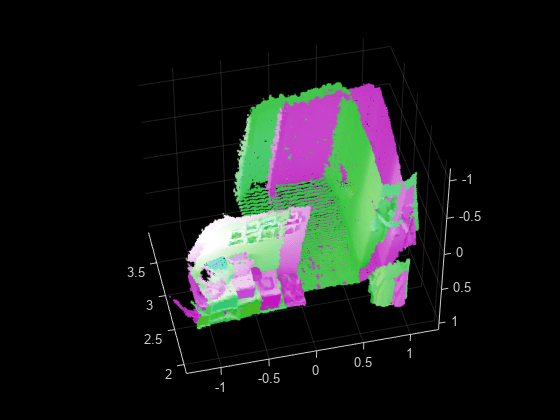
Register the point clouds.

gridStep = 0.5;
tform = pcregisterloam(movingPtCloud,fixedPtCloud,gridStep);

Align and visualize the point clouds.

alignedPtCloud = pctransform(movingPtCloud, tform);
figure
pcshowpair(alignedPtCloud,fixedPtCloud,'VerticalAxis','Y','VerticalAxisDir','Down')

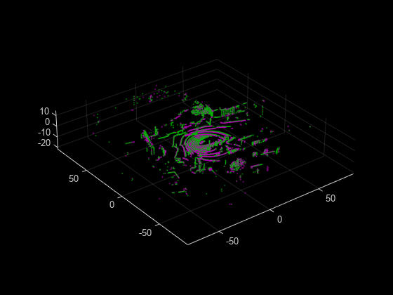
Read point cloud data from a Velodyne PCAP file into the workspace.

veloReader = velodyneFileReader("lidarData_ConstructionRoad.pcap","HDL32E");

Read the first point cloud from the data. Use this point cloud as the fixed point cloud.

fixedPtCloud = readFrame(veloReader,1);

Detect LOAM feature points in the fixed point cloud.

fixedPoints = detectLOAMFeatures(fixedPtCloud);

Downsample the less planar surface points from the fixed point cloud, to improve registration speed.

gridStep = 1;
fixedPoints = downsampleLessPlanar(fixedPoints,gridStep);

Read and detect LOAM feature points from the fifth point cloud in the data. Use this point cloud as the moving point cloud.

movingPtCloud = readFrame(veloReader,5);
movingPoints = detectLOAMFeatures(movingPtCloud);

Downsample the less planar surface points from the moving point cloud.

movingPoints = downsampleLessPlanar(movingPoints,gridStep);

Register the moving point cloud to the fixed point cloud.

tform = pcregisterloam(movingPoints,fixedPoints);

Transform the moving point cloud to align it to the fixed point cloud.

alignedPtCloud = pctransform(movingPtCloud,tform);

Visualize the aligned point clouds. Points from the fixed point cloud display as green, while points from the moving point cloud display as magenta.

figure
pcshowpair(alignedPtCloud,fixedPtCloud)

Input Arguments

collapse all

Organized moving point cloud, specified as a pointCloud object. The point cloud object must contain an organized point cloud with a Location property of size M-by-N-by-3 matrix, where M is the number of laser scans and N is the number of points per scan. The first page represents the x-coordinates, the second page represents the y-coordinates, and the third page represents the z- coordinates for each point.

Organized fixed point cloud, specified as a pointCloud object. The point cloud object must contain an organized point cloud with a Location property of size M-by-N-by-3 matrix, where M is the number of laser scans and N is the number of points per scan. The first page represents the x-coordinates, the second page represents the y-coordinates, and the third page represents the z- coordinates for each point.

Moving LOAM points, specified as a LOAMPoints object. You can obtain the LOAM points from the moving point cloud by using the detectLOAMFeatures function, which detects LOAM feature points from organized point clouds.

Fixed LOAM points, specified as a LOAMPoints object. You can obtain the LOAM points from the fixed point cloud by using the detectLOAMFeatures function, which detects LOAM feature points from organized point clouds.

Size of the 3-D box for downsampling the detected LOAM points in the input point cloud, specified as a positive scalar.

Name-Value Arguments

Specify optional pairs of arguments as Name1=Value1,...,NameN=ValueN, where Name is the argument name and Value is the corresponding value. Name-value arguments must appear after other arguments, but the order of the pairs does not matter.

Example: pcregisterloam(movingPoints,fixedPoints,MatchingMethod='one-to-one') sets the registration matching method to 'one-to-one'.

Initial rigid transformation, specified as a rigidtform3d object. Set the initial transformation to a coarse estimate. If you do not provide a coarse or initial estimate, the function uses a rigidtform3d object that contains a translation that moves the center of the moving points to the center of the fixed points.

Matching method, specified as 'one-to-one' or 'one-to-many'.

  • 'one-to-one' — The algorithm selects the nearest neighbor as a match.

  • 'one-to-many' — The algorithm selects multiple nearest neighbors within the specified search radius as matches. Using the 'one-to-many' method can increase registration accuracy, but at the cost of processing speed.

Search radius for point matching, specified as a positive integer. When matching, the function finds the closest edge and surface points within the specified radius. For best results, set this value based on the certainty of the InitialTransform. Increase the value of the SearchRadius when there is greater uncertainty in the initial transformation, but this can also decrease the registration speed.

Maximum iterations before LOAM registration stops, specified as a positive integer.

Tolerance between consecutive LOAM iterations, specified as a two-element vector with nonnegative values. The vector, [Tdiff Rdiff].

  • Tdiff — Tolerance for the estimated absolute difference in translation and rotation estimated in consecutive LOAM iterations. Measures the Euclidean distance between two translation vectors.

  • Rdiff — Tolerance for the estimated absolute difference of the angular rotation between consecutive iterations, measured in degrees.

The algorithm stops when the difference between the estimates of the rigid transformations in the most recent consecutive iterations falls below the specified tolerance value.

Display progress information, specified as a numeric or logical 0 (false) or 1 (true). To display progress information, set Verbose to true.

Output Arguments

collapse all

Rigid 3-D transformation, returned as a rigidtform3d object. tform describes the rigid 3-D transformation that registers the moving points to the fixed points.

Root mean squared error, returned as a positive scalar that represents the Euclidean distance between aligned points. A lower rmse value indicates a more accurate registration.

References

[1] Zhang, Ji, and Sanjiv Singh. “LOAM: Lidar Odometry and Mapping in Real-Time.” In Robotics: Science and Systems X. Robotics: Science and Systems Foundation, 2014. https://doi.org/10.15607/RSS.2014.X.007.

Extended Capabilities

Version History

Introduced in R2022a

expand all