geocode
Syntax
Description
Use Online Provider and Installed List of Placenames
geocodedGT = geocode(name)
The function geocodes the specified placename by using an online provider and an
installed list of world regions, US states, and world cities. For more information about
how geocode uses the online provider and the installed list, see
Algorithms.
geocodedGT = geocode(name,adminlevel)
Use Custom Table of Placenames
geocodedGT = geocode(name,customNamesGT)name table variable. If the table does not have a
name table variable, then the function searches the second table
variable.
geocodedGT = geocode(name,customNamesGT,namevar)
Additional Options
geocodedGT = geocode(___,Name=Value)FilterResults name-value argument.
Examples
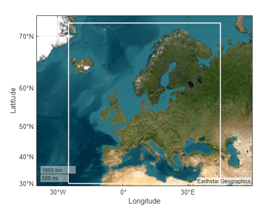
Geocode the world region of Europe. The output is a geospatial table that contains the geocoded placename, a shape object associated with the geocoded placename, and the administrative level of the geocoded placename.
geocodedGT = geocode("Europe")geocodedGT=1×3 table
Shape Name AdminLevel
____________ ________ __________
geopolyshape "Europe" "region"
When you geocode the name of a world region, the shape object is an area of interest (AOI) that represents either an outline or a quadrangle that approximates the region. Display the boundary of the AOI on a map. Provide more geographic context for the AOI by zooming out.
figure
geobasemap topographic
geoplot(geocodedGT,LineWidth=2,EdgeColor="#7E2F8E",FaceColor="none")
geolimits([15 75],[-54 75])
Specify placenames for the states that comprise New England: Maine, New Hampshire, Vermont, Massachusetts, Connecticut, and Rhode Island. Then, geocode the placenames. The output is a geospatial table that contains the geocoded placenames, the shape objects associated with the placenames, and the administrative levels of the placenames.
names = ["Maine","New Hampshire","Vermont","Massachusetts","Connecticut","Rhode Island"];
geocodedGT = geocode(names,"state")
geocodedGT=6×3 table
       Shape             Name          AdminLevel
    ____________    _______________    __________

    geopolyshape    "Maine"             "state"
    geopolyshape    "New Hampshire"     "state"
    geopolyshape    "Vermont"           "state"
    geopolyshape    "Massachusetts"     "state"
    geopolyshape    "Connecticut"       "state"
    geopolyshape    "Rhode Island"      "state"
When you geocode the names of US states, the shape objects are AOIs that represent the outlines of the states. Display the AOIs on a map.
figure
geobasemap none
geoplot(geocodedGT)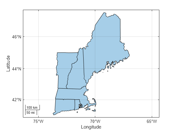
Since R2025a
Geocode the placename Essex using the county administrative level. The output is geospatial table that contains several matches for the placename, including Essex County in Massachusetts.
GT1 = geocode("Essex","county")
GT1=6×3 table
       Shape                 Name              AdminLevel
    ____________    _______________________    __________

    geopolyshape    "Essex, England, GBR"       "county"
    geopolyshape    "Essex County, MA, USA"     "county"
    geopolyshape    "Essex County, NJ, USA"     "county"
    geopolyshape    "Essex County, NY, USA"     "county"
    geopolyshape    "Essex County, VT, USA"     "county"
    geopolyshape    "Essex County, VA, USA"     "county"
Create a new geospatial table that contains only the result for Massachusetts.
GT2 = geocode("Essex County, MA","county")
GT2=1×3 table
       Shape                 Name              AdminLevel
    ____________    _______________________    __________

    geopolyshape    "Essex County, MA, USA"     "county"
When you geocode the name of a county, the Shape variable of the table is an AOI that approximates the region. Display the AOI on a map.
figure
geobasemap streets
geoplot(GT2)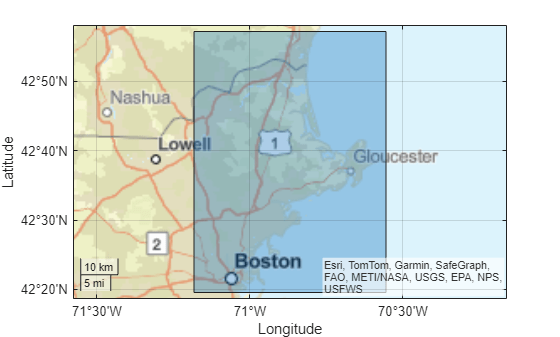
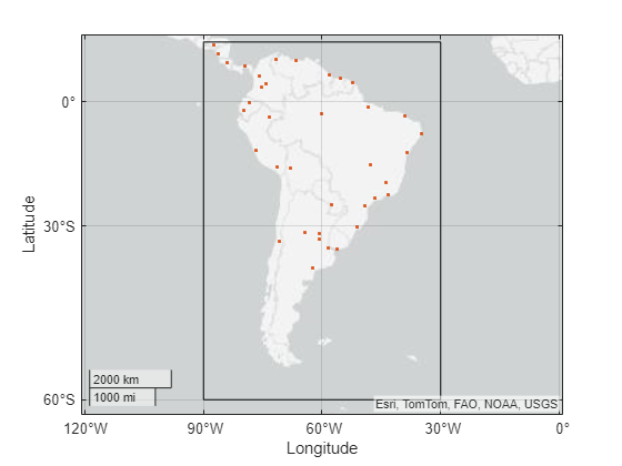
Geocode all the world cities in the installed list of placenames. Then, clip the cities to an AOI.
Get the names of world cities in the installed list by using the placenames function.
names = placenames("city");Geocode the placenames. When you specify multiple placenames and the "city" administrative level, the geocode function searches the installed list of placenames instead of using the online provider.
geocodedGT = geocode(names,"city");View the first eight rows of the output table. When you geocode the names of cities, the shape objects in the output table are points that represent the city locations.
head(geocodedGT)
             Shape                 Name         AdminLevel
    _______________________    _____________    __________

    ( 5.2985°N,   3.9509°W)    "Abidjan"          "city"
    (24.6525°N,  54.7589°E)    "Abu Dhabi"        "city"
    ( 5.6106°N,   0.2121°W)    "Accra"            "city"
    (37.0613°N,  35.3894°E)    "Adana"            "city"
    ( 9.0235°N,  38.7575°E)    "Addis Ababa"      "city"
    (34.6645°S, 138.8528°E)    "Adelaide"         "city"
    (12.8767°N,  44.5408°E)    "Aden"             "city"
    (22.7778°N,  72.2474°E)    "Ahmadabad"        "city"
Prepare to clip the world cities by extracting the points from the table.
points = geocodedGT.Shape;
Get an AOI that represents a bounding box for South America. Then, clip the world cities to the AOI. For more information about clipping shapes to AOIs, see Clip Vector Data to Area of Interest.
GT = geocode("South America");
aoi = GT.Shape;

clipped = geoclip(points,aoi);
Display the AOI and the clipped cities on a map.
figure
geoplot(aoi,FaceColor="none")
hold on
geoplot(clipped)
Since R2025a
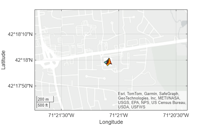
Geocode the address of the MathWorks Apple Hill campus.
geocodedGT = geocode("1 Apple Hill Drive, Natick, MA","address")
geocodedGT=1×3 table
            Shape                                 Name                        AdminLevel
    ______________________    ____________________________________________    __________

    (42.2998°N, 71.3516°W)    "1 Apple Hill Drive, Natick, MA, 01760, USA"    "address"
When you geocode an address, the output table contains a point shape in geographic coordinates. Display an icon at the coordinates stored in the point shape.
lat = geocodedGT.Shape.Latitude;
lon = geocodedGT.Shape.Longitude;
geoiconchart(lat,lon,"matlabicon.gif")
Zoom in by changing the geographic limits.
geolimits([42.2946 42.3054],[-71.3622 -71.34])
Since R2025a
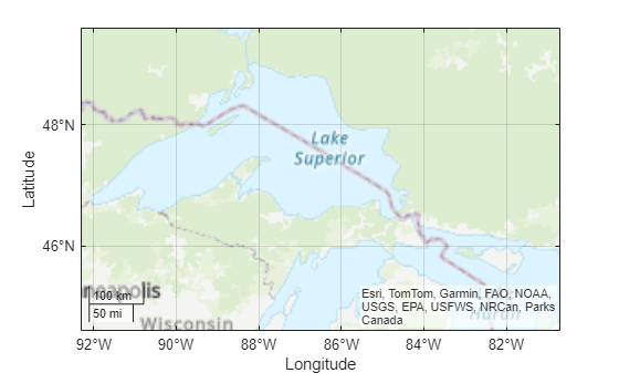
Geocode the placename Lake Superior, MI using the administrative level for physical features.
geocodedGT = geocode("Lake Superior, MI","physical")
geocodedGT=1×3 table
       Shape                  Name              AdminLevel
    ____________    ________________________    __________

    geopolyshape    "Lake Superior, MI, USA"    "physical"
When you geocode the name of a physical feature, the Shape variable of the table contains an AOI that represents a quadrangle. View a map of the region by plotting the AOI with no face or edge color.
figure
geobasemap topographic
geoplot(geocodedGT,FaceColor="none",EdgeColor="none")
Create a custom table of placenames by reading data from a file. Then, use the custom table to geocode a specified placename.
Create the custom table by reading data from a shapefile that contains placenames in Boston. The table stores the placenames in the NAME variable and the locations of the placenames in the Shape variable.
customNamesGT = readgeotable("boston_placenames.shp")customNamesGT=13×4 table
Shape NAME FEATURE COORD
______________________ ____________________ _____________ _________________
(234028.23, 900038.00) "'BACK BAY'" "PPL-SUBDVSN" "422100N0710515W"
(233569.77, 900190.06) "BACK BAY FENS" "MARSH" "422105N0710535W"
(235739.28, 901126.44) "BEACON HILL" "HILL" "422135N0710400W"
(236266.39, 900974.88) "BOSTON" "PPL" "422130N0710337W"
(235743.22, 900355.06) "BOSTON NECK" "PENINSULA" "422110N0710400W"
(234685.09, 901429.69) "BROAD CANAL" "CANAL" "422145N0710446W"
(232989.64, 901884.31) "CAMBRIDGE" "PPL" "422200N0710600W"
(236536.17, 901901.88) "COPPS HILL" "HILL" "422200N0710325W"
(234591.28, 901892.00) "'EAST CAMBRIDGE'" "PPL-SUBDVSN" "422200N0710450W"
(235741.66, 900663.62) "FLAGSTAFF HILL" "HILL" "422120N0710400W"
(237114.73, 900670.75) "FORT POINT CHANNEL" "CHANNEL" "422120N0710300W"
(235741.31, 900725.31) "FROG POND" "LAKE" "422122N0710400W"
(236548.23, 899587.88) "SOUTH BAY" "INLET" "422045N0710325W"
Specify the placenames of two hills in Boston. Then, geocode the placenames by searching the custom table. By default, the geocode function searches for the placenames using the NAME variable of the custom table.
names = ["BEACON HILL","COPPS HILL"];
geocodedGT = geocode(names,customNamesGT);
View the output table. When you pass a custom table of placenames to the geocode function, the output table is a subset of the input table.
geocodedGT
geocodedGT=2×4 table
            Shape                 NAME         FEATURE          COORD
    ______________________    _____________    _______    _________________

    (235739.28, 901126.44)    "BEACON HILL"    "HILL"     "422135N0710400W"
    (236536.17, 901901.88)    "COPPS HILL"     "HILL"     "422200N0710325W"
Create a custom table of placenames by reading data from a file. Then, geocode a specified placename by searching the specified table variable of placenames.
Create the custom table by reading data from a shapefile that contains tsunami events. The table stores the placenames in the Location variable and the shape objects in the Shape variable.
customNamesGT = readgeotable("tsunamis.shp",CoordinateSystemType="geographic");
head(customNamesGT)
             Shape             Year    Month    Day    Hour    Minute    Second    Val_Code           Validity            Cause_Code         Cause          Eq_Mag         Country                 Location            Max_Height    Iida_Mag    Intensity    Num_Deaths    Desc_Deaths
    _______________________    ____    _____    ___    ____    ______    ______    ________    _______________________    __________    ________________    ______    _________________    ________________________    __________    ________    _________    __________    ___________

    ( 3.8000°S, 128.3000°E)    1950     10       8       3       23       NaN         2        "questionable tsunami"         1         "Earthquake"         7.6      "INDONESIA"          "JAVA TRENCH, INDONESIA"        2.8         1.5          1.5             0            0
    (19.5000°N, 156.0000°W)    1951      8      21      10       57       NaN         4        "definite tsunami"             1         "Earthquake"         6.9      "USA"                "HAWAII"                        3.6         1.8          NaN             0            0
    ( 9.0200°S, 157.9500°E)    1951     12      22       0        0       NaN         2        "questionable tsunami"         6         "Volcano"            NaN      "SOLOMON ISLANDS"    "KAVACHI"                         6         2.6          NaN             0            0
    (42.1500°N, 143.8500°E)    1952      3       4       1       22        41         4        "definite tsunami"             1         "Earthquake"         8.1      "JAPAN"              "SE. HOKKAIDO ISLAND"           6.5         2.7            2            33            1
    (19.1000°N, 155.0000°W)    1952      3      17       3       58       NaN         4        "definite tsunami"             1         "Earthquake"         4.5      "USA"                "HAWAII"                          1         NaN          NaN             0            0
    (43.1000°N,  82.4000°W)    1952      5       6       0        0       NaN         1        "very doubtful tsunami"        9         "Meteorological"     NaN      "USA"                "LAKE HURON, MI"               1.52         NaN          NaN             0            0
    (52.7500°N, 159.5000°E)    1952     11       4      16       58       NaN         4        "definite tsunami"             1         "Earthquake"           9      "RUSSIA"             "KAMCHATKA"                      18         4.2            4          2236            3
    (50.0000°N, 156.5000°E)    1953      3      18       0        0       NaN         3        "probable tsunami"             1         "Earthquake"         5.8      "RUSSIA"             "N. KURIL ISLANDS"              1.5         0.6          NaN             0            0
Geocode the placename Hawaii by searching the custom table. Specify the table variable containing the placenames as Location.
name = "Hawaii";
geocodedGT = geocode(name,customNamesGT,"Location");
View the output table. When you pass a custom table of placenames to the geocode function, the output table is a subset of the input table.
geocodedGT
geocodedGT=3×19 table
             Shape             Year    Month    Day    Hour    Minute    Second    Val_Code         Validity         Cause_Code              Cause               Eq_Mag    Country    Location    Max_Height    Iida_Mag    Intensity    Num_Deaths    Desc_Deaths
    _______________________    ____    _____    ___    ____    ______    ______    ________    __________________    __________    __________________________    ______    _______    ________    __________    ________    _________    __________    ___________

    (19.5000°N, 156.0000°W)    1951      8      21      10       57        NaN        4        "definite tsunami"        1         "Earthquake"                   6.9       "USA"     "HAWAII"        3.6         1.8          NaN           0              0
    (19.1000°N, 155.0000°W)    1952      3      17       3       58        NaN        4        "definite tsunami"        1         "Earthquake"                   4.5       "USA"     "HAWAII"          1         NaN          NaN           0              0
    (19.3340°N, 155.0240°W)    1975     11      29      14       47       40.4        4        "definite tsunami"        3         "Earthquake and Landslide"     7.1       "USA"     "HAWAII"       14.3           3            3           2              1
Since R2025a
In many cases, the geocode function finds multiple matches for a specified placename. To return the first match, specify the FilterResults argument as "first".
Geocode the placename Essex using the county administrative level. Include only the first result in the output table.
geocodedGT = geocode("Essex","county",FilterResults="first")
geocodedGT=1×3 table
       Shape                Name             AdminLevel
    ____________    _____________________    __________

    geopolyshape    "Essex, England, GBR"     "county"
Since R2025a
When you do not specify an administrative level, the geocode function searches the administrative levels in this order: "region", "state", "country", "city", "address", and "physical". By default, the function returns results for one administrative level, which is the first administrative level with matches. To return results for all the administrative levels, specify the FilterResults argument as "none".
Geocode the placename Pacific and return results for all the administrative levels.
geocodedGT = geocode("Pacific",FilterResults="none")
geocodedGT=9×3 table
        Shape                  Name               AdminLevel
    _____________    _________________________    __________

    geopolyshape     "Pacific"                    "region"
    geopolyshape     "Pacific Ocean"              "region"
    geopolyshape     "Pacific County, WA, USA"    "county"
    geopointshape    "Pacific, MO, USA"           "city"
    geopointshape    "Pacific, WA, USA"           "city"
    geopointshape    "Pacific, WI, USA"           "city"
    geopointshape    "Pacific, NC, USA"           "city"
    geopointshape    "Pacific, CA, USA"           "city"
    geopolyshape     "Pacific, BC, CAN"           "physical"
The output table contains matches for regions, counties, cities, and physical features. The function did not find matches for the state or address administrative levels.
Since R2025a
By default, the geocode function filters results from the online provider by applying partial string matching of leading characters. You can view unfiltered results from the online provider by specifying the PartialMatching name-value argument as false.
Geocode the placename Mount Fuji using the administrative level for physical features. By default, the function filters the results.
filteredGT = geocode("Mount Fuji","physical")
filteredGT=1×3 table
       Shape              Name           AdminLevel
    ____________    _________________    __________

    geopolyshape    "Mount Fuji, JPN"    "physical"
Geocode the placename again. This time, return the unfiltered results. The geospatial table contains additional results from the online provider.
unfilteredGT = geocode("Mount Fuji","physical",PartialMatch=false)
unfilteredGT=9×3 table
       Shape                           Name                        AdminLevel
    ____________    ___________________________________________    __________

    geopolyshape    "Mount Fuji, JPN"                              "physical"
    geopolyshape    "Mt. Fuji, Hidaka, Saitama, JPN"               "physical"
    geopolyshape    "Mt. Fuji, Minokamo, Gifu, JPN"                "physical"
    geopolyshape    "Mt. Fuji, Nasushiobara, Tochigi, JPN"         "physical"
    geopolyshape    "Mt. Fuji, Yokosuka, Kanagawa, JPN"            "physical"
    geopolyshape    "Mt. Fuji, Nishiaizu, Yama, Fukushima, JPN"    "physical"
    geopolyshape    "Mt. Fuji, Kasama, Ibaraki, JPN"               "physical"
    geopolyshape    "Mt. Fuji, Ueda, Nagano, JPN"                  "physical"
    geopolyshape    "Mt. Fuji, Gotemba, Shizuoka, JPN"             "physical"
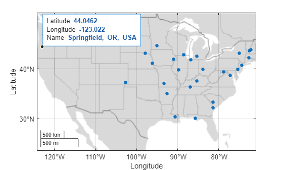
Explore geocoded placenames on a map using custom data tips.
Geocode the placename Springfield using the city administrative level. Create a subtable of cities in the conterminous United States. The table stores the geocoded cities using point shapes in geographic coordinates.
cities = geocode("Springfield","city");

us = geocode("United States (conterminous)");
idx = isinterior(us.Shape,cities.Shape);
citiesInUS = cities(idx,:);
Display the cities on a map. Prepare to add data tips to the points by storing the Point object in pt.
figure
geobasemap grayland
pt = geoplot(citiesInUS,MarkerSize=15);
Add the geocoded placenames to the data tip template. For more information about creating custom data tips, see Add Data Tips to Point, Line, and Polygon Shapes.
dtRow = dataTipTextRow("Name",citiesInUS.Name);
pt.DataTipTemplate.DataTipRows(end+1) = dtRow;
Create a data tip by using the datatip function, the Point object, and the geographic coordinates of a city. You can also add data tips by pausing on, clicking, or tapping the points.
dt = datatip(pt,44,-123);
Input Arguments
Name-Value Arguments
Output Arguments
Limitations
When the geocode function uses the online provider, deployment using
MATLAB®
Compiler™ is not supported. For information about when the function uses the online
provider, see Algorithms.
More About
Tips
The online provider updates the data periodically. As a result, the
geocodefunction can return different results over time.In offline environments:
Geocoding the names of regions, states, and cities is limited to the installed list of placenames. You can query the installed list by using the
placenamesfunction.Geocoding the names of counties, addresses, and physical features is not supported.