height
Description
hgt = height(surface,pt)hgt of the point pt on the
surface. This syntax applies when the surface is a LandSurface,
SeaSurface, or
CustomSurface
object.
hgt = height(surface,pt,t)hgt of the point pt on the
surface at the time t. This syntax only applies
when the surface is a SeaSurface
object.
Examples
Create a square sea surface area using the seaSurface object. Assume a moderate sea state with a wind speed of about 10 m/s, a fetch of 250 km and a length of 1.0 km. Add an Elfouhaily spectrum to the sea surface. Use the height function to determine the heights of 2 points on the map.
Create a radar scenario.
scene = radarScenario(IsEarthCentered = false);
rng('default')
Add a sea surface to the scene with an Elfouhaily spectrum.
spec = seaSpectrum(Resolution = 20);
srf = seaSurface(scene,Boundary = [-500 500; -500 500], ...
    WindSpeed = 10,Fetch = 250000,SpectralModel = spec);
Find the height at two points.
P1 = [0;0];
P2 = [30;-70];
H = height(srf,[P1 P2])
H = 1×2

   -0.9394   -0.2682
Display the sea surface properties in the surface manager.
mgr = scene.SurfaceManager
mgr =
  SurfaceManager with properties:

    EnableMultipath: 0
       UseOcclusion: 1
           Surfaces: [1×1 radar.scenario.SeaSurface]
mgr.Surfaces
ans =
  SeaSurface with properties:

                WindSpeed: 10
            WindDirection: 0
                    Fetch: 250000
            SpectralModel: [1×1 seaSpectrum]
        RadarReflectivity: [1×1 surfaceReflectivitySea]
    ReflectionCoefficient: [1×1 radar.scenario.SurfaceReflectionCoefficient]
          ReflectivityMap: 1
          ReferenceHeight: 0
                 Boundary: [2×2 double]
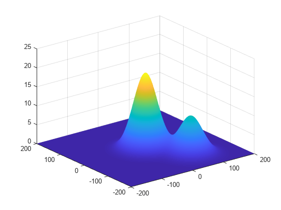
Create a radar scenario. Add a 400-by-400 m area to the scenario with two simulated hills. Find the height of two points.
scene = radarScenario('IsEarthCentered',false);
bnds = [-200 200; -200, 200];
x = -200:200;
y = -200:200;
[X,Y] = meshgrid(x,y);
htmap = 20*exp(-X.^2/2000 - Y.^2/2000) + 10*exp(-(X-70).^2/2000 - (Y+100).^2/2000);
surf(X,Y,htmap)
shading interp

Find the height of the surface at two points.
P1 = [0.0; 0.0]; % Point 1
P2 = [28.0; -40.0];  % Point 2
srf = landSurface(scene,'Terrain',htmap,'Boundary',bnds)
srf =
  LandSurface with properties:

        RadarReflectivity: [1×1 surfaceReflectivityLand]
    ReflectionCoefficient: [1×1 radar.scenario.SurfaceReflectionCoefficient]
          ReflectivityMap: 1
          ReferenceHeight: 0
                 Boundary: [2×2 double]
                  Terrain: [401×401 double]
H = height(srf,[P1 P2])
H = 1×2

   20.0058    6.7565
Use the surface manager find the surfaces in the scenario.
mgr = scene.SurfaceManager
mgr =
  SurfaceManager with properties:

    EnableMultipath: 0
       UseOcclusion: 1
           Surfaces: [1×1 radar.scenario.LandSurface]
mgr.Surfaces
ans =
  LandSurface with properties:

        RadarReflectivity: [1×1 surfaceReflectivityLand]
    ReflectionCoefficient: [1×1 radar.scenario.SurfaceReflectionCoefficient]
          ReflectivityMap: 1
          ReferenceHeight: 0
                 Boundary: [2×2 double]
                  Terrain: [401×401 double]
Input Arguments
Surface, specified as a LandSurface,
SeaSurface, or
CustomSurface
object.
Points on surface, specified as 2-by-N matrix of real values or a 3-by-N matrix of real values, where N is the number of points.
The coordinate system of the point depends on the value of the
IsEarthCentered property of the radar scenario object::
false— Each column of the 2-by-N matrix represents the x- and y-coordinates of points in meters. Each column of the 3-by-N matrix represents the x-, y-, and z-coordinates in meters. Note that the z-coordinate is irrelevant for surface height querying.true— Each column of the 2-by-N matrix is the latitude in degrees and longitude in degrees, in the geodetic frame. Each column of the 3-by-N matrix is the latitude in degrees, longitude in degrees, and altitude in degrees, in geodetic coordinates. Note that the latitude is irrelevant for surface height querying.
Simulation time, specified as a scalar.
Dependencies
To enable this argument, select surface as a SeaSurface
object.
Data Types: double
Output Arguments
Height of point, returned as a scalar or an N-element vector of real values, where N is the number of queried positions. Units are in meters.
Version History
Introduced in R2022a
See Also
LandSurface | SeaSurface | CustomSurface | occlusion | SurfaceManager
MATLAB Command
You clicked a link that corresponds to this MATLAB command:
Run the command by entering it in the MATLAB Command Window. Web browsers do not support MATLAB commands.
选择网站
选择网站以获取翻译的可用内容,以及查看当地活动和优惠。根据您的位置,我们建议您选择:。
您也可以从以下列表中选择网站:
如何获得最佳网站性能
选择中国网站(中文或英文)以获得最佳网站性能。其他 MathWorks 国家/地区网站并未针对您所在位置的访问进行优化。
美洲
- América Latina (Español)
- Canada (English)
- United States (English)
欧洲
- Belgium (English)
- Denmark (English)
- Deutschland (Deutsch)
- España (Español)
- Finland (English)
- France (Français)
- Ireland (English)
- Italia (Italiano)
- Luxembourg (English)
- Netherlands (English)
- Norway (English)
- Österreich (Deutsch)
- Portugal (English)
- Sweden (English)
- Switzerland
- United Kingdom (English)