occlusion
Description
Examples
Create a radar scenario and specify set the IsEarthCentered property as true to obtain the terrain from a DTED file.
scene = radarScenario(IsEarthCentered = true);
Model the reflectivity as a constant gamma surface.
refl = surfaceReflectivityLand(Model = 'ConstantGamma',Gamma = -20);Add a 0.1-by-0.1 degree land surface derived from a DTED file.
bdry = [39.5 39.6;-105.51 -105.41];
srf = landSurface(scene,Terrain = 'n39_w106_3arc_v2.dt1', ...
    Boundary = bdry,RadarReflectivity = refl);
Verify that occlusion is turned on.
mgr = scene.SurfaceManager
mgr =
  SurfaceManager with properties:

    EnableMultipath: 0
       UseOcclusion: 1
           Surfaces: [1×1 radar.scenario.LandSurface]
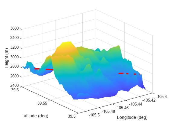
Plot the surface height.
x = linspace(srf.Boundary(2,1),srf.Boundary(2,2),201);
y = linspace(srf.Boundary(1,1),srf.Boundary(1,2),201);
[X,Y] = meshgrid(x,y);
X1 = X(:)';
Y1 = Y(:)';
H = height(srf,[Y1;X1]);
H = reshape(H,length(x),length(y));
surf(x,y,H)
shading interp
ylabel('Latitude (deg)')
xlabel('Longitude (deg)')
zlabel('Height (m)')
hold on
Test for occlusion.
ht1 = height(srf,[39.59 -105.5])
ht1 =
2.7962e+03
ht2 = height(srf,[39.51 -105.41])
ht2 =
2.7718e+03
occlusion(srf,[39.59 -105.5 ht1],[39.51 -105.41 ht2])
ans = logical
   1
The points are occluded. The line between the two points passes through the surface as shown.
plot3([-105.5 -105.41],[39.59 39.51], [ht1 ht2],'r','LineWidth',3)

Create a square sea surface assuming a moderate sea state with a wind speed of about 12 knots (6.17 m/s), a fetch of 120 nmi (222.24 km), and a length of 1.024 km. Add an Elfouhaily spectrum to the sea surface. Use the occlusion object function to determine if the path from point 1 to point 2 is occluded.
Start by creating a radar scenario;
scene = radarScenario;
Add a sea surface with an Elfouhaily spectrum.
rng('default');
spec = seaSpectrum('Resolution',16);
Create the sea surface.
bnds = [0 1024; 0 1024];
srf = seaSurface(scene,'Boundary',bnds, ...
    'WindSpeed',6.17,'Fetch',222.24e3, ...
    'SpectralModel',spec);
Set two points for testing occlusion.
p1 = [1016; 368; -0.082];
p2 = [10; 100; 0.13];
Determine if the path from p1 to p2 is occluded
tf1 = occlusion(srf,p1,p2)
tf1 = logical
   1
Input Arguments
Surface, specified as a LandSurface,
SeaSurface, or
CustomSurface
object.
Position of the first point on a surface, specified as a length-3 real-valued vector.
If the IsEarthCentered property of the radarScenario
object is specified as:
false— Specify the three elements as the x-, y-, and z-coordinates in the reference frame of the tracking scenario. Units are in meters.true— Specify the three elements as the latitude in degrees, longitude in degrees, and altitude in meters, in the geodetic frame.
Data Types: double
Position of the second point on a surface, specified as a length-3 real-valued vector.
If the IsEarthCentered property of the radarScenario
object is specified as:
false— Specify the three elements as the x-, y-, and z-coordinates in the reference frame of the tracking scenario. Units are in meters,true— Specify the three elements as the latitude in degrees, longitude in degrees, and altitude in meters, in the geodetic frame.
Data Types: double
Output Arguments
Occlusion status, returned as a logical 1
(true) representing occluded, or 0
(false) representing not occluded.
Version History
Introduced in R2022a
See Also
MATLAB Command
You clicked a link that corresponds to this MATLAB command:
Run the command by entering it in the MATLAB Command Window. Web browsers do not support MATLAB commands.
选择网站
选择网站以获取翻译的可用内容,以及查看当地活动和优惠。根据您的位置,我们建议您选择:。
您也可以从以下列表中选择网站:
如何获得最佳网站性能
选择中国网站(中文或英文)以获得最佳网站性能。其他 MathWorks 国家/地区网站并未针对您所在位置的访问进行优化。
美洲
- América Latina (Español)
- Canada (English)
- United States (English)
欧洲
- Belgium (English)
- Denmark (English)
- Deutschland (Deutsch)
- España (Español)
- Finland (English)
- France (Français)
- Ireland (English)
- Italia (Italiano)
- Luxembourg (English)
- Netherlands (English)
- Norway (English)
- Österreich (Deutsch)
- Portugal (English)
- Sweden (English)
- Switzerland
- United Kingdom (English)