Grid Surface

Libraries:
Simscape /
Multibody /
Curves and Surfaces
Description
The Grid Surface block creates a Cartesian grid surface that you can use to model contact problems. You can model contacts between the grid surface and various types of geometries. For the supported geometries, see Supported Geometries. In addition, the Grid Surface block supports the Custom Tire Force and Torque and Magic Formula Tire Force and Torque blocks.
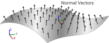
You must use the positive normal side of the grid surface for contact, which the positive z-axis of the reference frame points to. Otherwise, the block ejects the contacting part through the surface to the positive side.
The grid surface has a similar format to the grid generated by the ndgrid function in MATLAB®. To model a grid surface, use the X Grid Vector and Y Grid Vector parameters to specify
the coordinates in the x and y directions of the
grid surface, then use the Z Heights parameter to specify
the elevations of the grid points in the z direction. You can use the
block to create a surface that represents a square, rectangular, or non-uniform
grid.

The image shows an illustration of a grid surface whose Z Heights
parameter is [0 0 0.5 0.5; 0 0 0.5 0.5; 0 0 0 0; 0 0 0 0]. The
columns of the matrix are along the x-axis, and the rows of the
matrix are along the y-axis.

To create a grid surface using LiDAR data, you must convert the scattered data to gridded
data before using it in the Grid Surface block. To
convert the data, you can use a scatteredInterpolant object to create an
interpolant function by using the x, y, and
z values of the LiDAR data, create x and
y grid vectors that represent the domain of the grid, and then
use the grid vectors as the query points of the interpolant function to produce
z values for the grid surface. The produced z
values form a matrix in the ndgrid format that you can use to
specify the Z Heights parameter. You can also use the griddata function to produce z values for a grid
surface, but you need to transpose the output matrix to the ndgrid
format.
Note
For the best simulation performance, make the spacing in the x
and y grid vectors as large as possible while also being small
enough to represent the surface with sufficient accuracy. To change the spacing of
the grid vectors and compute the corresponding z values , use the
griddedInterpolant object or interp2 function.
Generally, you need to clean the LiDAR data before converting it to gridded data, such as
removing outliers or NaN values. To clean the data, use the isnan and isoutlier functions.
Examples
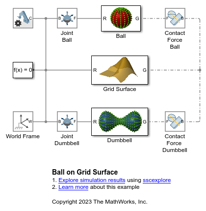
Contact Modeling - Ball on Grid Surface
A ball and dumbbell rolling down on an L-shaped surface. Grid Surface block is used to generate the L-shaped membrane. Point Cloud blocks are used to model the contact between the ball/dumbbell and the surface. The number of point blocks can be controlled by varying the point cloud density. This example demonstrates the capabilities of Grid Surface and Point Cloud blocks to model contacts between complex shaped bodies.
Ports
Frame
Geometry
Parameters
Coordinates in the x-direction of the grid surface, specified as a real 1-by-m vector. m must be greater than 2, and the vector elements must be strictly monotonic and increasing. This vector corresponds to the rows of the matrix specified in the Z Heights parameter.

Coordinates in the y-direction of the grid surface, specified as a real 1-by-n vector. n must be greater than 2, and the vector elements must be strictly monotonic and increasing. This vector corresponds to the columns of the matrix specified in the Z Heights parameter.

Elevations of the grid points in the grid surface, specified as a real m-by-n matrix. m and n are the lengths of the vectors for the X Grid Vector and Y Grid Vector parameters.
Graphic
Visual representation of the grid surface. Set this parameter to From
Geometry to show the visual representation of the grid
surface. Set this parameter to None to hide
the grid surface in the model visualization.
Parameterizations for specifying visual properties. Select
Simple to specify diffuse color and
opacity. Select Advanced to specify more
visual properties, such as Specular Color,
Ambient Color, Emissive
Color, and Shininess.
Dependencies
To enable this parameter, set Type to
From Geometry.
Color of the graphic under direct white light, specified as an [R G B] or [R G B A] vector on a 0–1 scale. An optional fourth element (A) specifies the color opacity on a scale of 0–1. Omitting the opacity element is equivalent to specifying a value of 1.
Dependencies
To enable this parameter, set Type to From
Geometry.
Graphic opacity, specified as a scalar in the range of 0 to 1. A scalar of 0 corresponds to completely transparent, and a scalar of 1 corresponds to completely opaque.
Dependencies
To enable this parameter, set:
Type to
From GeometryVisual Properties to
Simple
Color of the specular highlights, specified as an [R,G,B] or [R,G,B,A] vector on a 0–1 scale. The optional fourth element specifies the color opacity. Omitting the opacity element is equivalent to specifying a value of 1.
Dependencies
To enable this parameter, set:
Type to
From
											Geometry
Visual Properties to
Advanced
Color of the shadow areas in diffuse ambient light, specified as an [R,G,B] or [R,G,B,A] vector on a 0–1 scale. The optional fourth element (A) specifies the color opacity. Omitting the opacity element is equivalent to specifying a value of 1.
Dependencies
To enable this parameter, set:
Type to
From
											Geometry
Visual Properties to
Advanced
Graphic color due to self illumination, specified as an [R,G,B] or [R,G,B,A] vector on a 0–1 scale. The optional fourth element (A) specifies the color opacity. Omitting the opacity element is equivalent to specifying a value of 1.
Dependencies
To enable this parameter, set:
Type to
From
											Geometry
Visual Properties to
Advanced
Sharpness of the specular light reflections, specified as a scalar number on a 0–128 scale. Increase the shininess value for smaller but sharper highlights. Decrease the value for larger but smoother highlights.
Dependencies
To enable this parameter, set:
Type to
From
											Geometry
Visual Properties to
Advanced
Version History
Introduced in R2021b
See Also
Spatial Contact
Force | Point Cloud | griddata | isnan | isoutlier | scatteredInterpolant | griddata | griddedInterpolant | interp2